Mount Pisgah Campground Review: Elevation, Weather, RV Fit & Showers (2026)
A verified Mount Pisgah Campground review covering its 4,980-foot elevation, month-by-month weather, 125 sites, showers, dry camping, exact rig fit and tunnel approach routes.

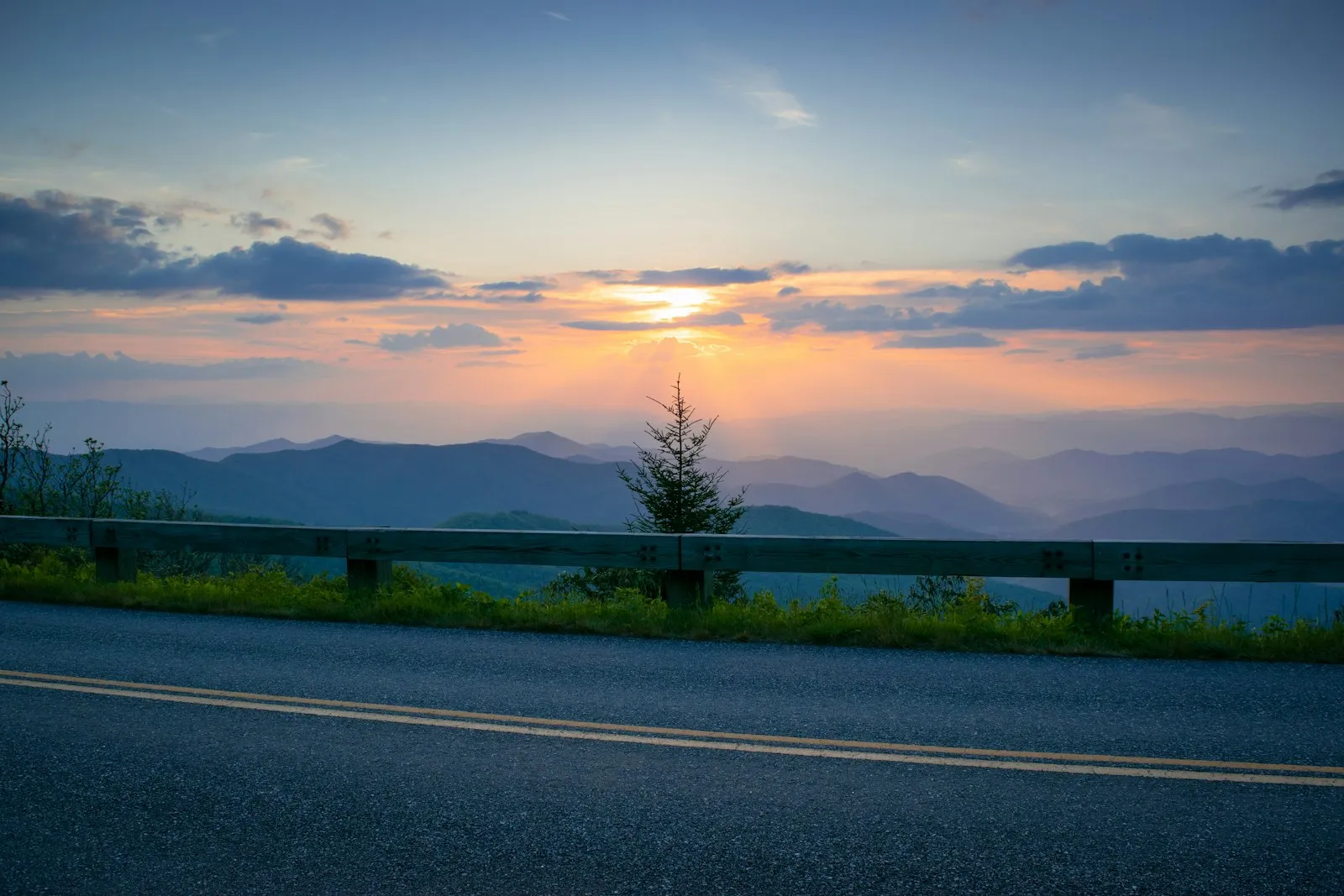
Mount Pisgah Campground is the highest developed campground on the Blue Ridge Parkway, sitting at 4,980 feet near milepost 408.8. NPS lists 125 sites, including 50 RV sites, and the 2026 fee is $30 per night. There are no hookups, but the campground has hot showers in Loops B and C, flush toilets, potable water and a dump station.
Quick answer: Mount Pisgah Campground weather is cool, damp and changeable — expect temperatures well below Asheville’s, frequent fog, fast-building afternoon storms and near-freezing nights in the shoulder months. Its elevation is 4,980 feet (1,518 meters), confirmed on Recreation.gov, the highest of any Parkway campground. Our review verdict: the best NPS campground on the Parkway for showers plus mountain scenery, at $30 a night, with no hookups, minimal cell service and a nine-tunnel approach from Asheville that tall RVs must plan around.
Verified July 26, 2026; elevation re-checked on Recreation.gov August 18, 2026: The 2026 season runs May 22 through October 25. Some sites are reservable up to six months ahead and others are first-come. Rig fit varies dramatically: official examples include 35-, 50- and 60-foot RV sites. Generator use is prohibited at all times in Loops C and D. Check the NPS campground page, Recreation.gov and live Parkway road status.
The honest verdict: Mount Pisgah is the Parkway’s best campground for campers who want high-elevation scenery and campground showers without leaving the NPS system. The campsite may fit a long RV, but the route is the harder question: the Asheville approach includes nine tunnels, so height and live closure checks are mandatory.
Mount Pisgah Campground at a glance
| Detail | 2026 information |
|---|---|
| Location | Blue Ridge Parkway MP 408.6/408.8 |
| Elevation | 4,980 ft (1,518 m) |
| Total sites | 125 |
| RV sites | 50 |
| Tent sites | 64 |
| Nightly fee | $30 |
| Hookups | None |
| Showers | Hot, seasonal; Loops B and C |
| Toilets | Flush, seasonal |
| Potable water | Yes, seasonal |
| Dump station | Yes, seasonal |
| Reservations | Some reservable; some first-come |
| Season | May 22–Oct. 25 |
| Cell/internet | NPS lists none; Recreation.gov says minimal |
| RV fit | Exact site and route control |
Mount Pisgah Campground elevation: why 4,980 feet matters
Recreation.gov lists the campground at 4,980 feet (1,518 meters), and it sits just below the 5,721-foot summit of Mount Pisgah itself. For context, downtown Asheville is roughly 2,100 feet, so you climb close to 3,000 vertical feet from town. That difference is not cosmetic. It is the reason the campground stays cool when the valleys bake, the reason fog rolls through the loops on otherwise clear days, and the reason the season is capped at late May through late October — the water systems and roads simply are not built for a Blue Ridge winter at this height.
Three practical consequences of the elevation:
- Temperature. As a rule of thumb, mountain air cools roughly 3–5°F for every 1,000 feet of elevation gain, so a Mount Pisgah afternoon usually runs about 10–15°F below Asheville. Recreation.gov’s own description is “moderate to cool temperatures during camping seasons.”
- Weather speed. Ridgelines at this height are where valley moisture condenses. Clouds form on the campground, not above it, and thunderstorms arrive with little warning.
- Engine and appliance behavior. Older gas motorhomes and tow vehicles lose some power on the climb, and propane appliances may run slightly less efficiently. Neither is a dealbreaker, but budget extra time on the grade.
If you want the Parkway experience without the altitude, Julian Price near Blowing Rock sits lower and warmer, and Peaks of Otter in Virginia is lower still.
Mt Pisgah Campground weather by month
The National Park Service does not publish a month-by-month climate table for the campground, so what follows is our qualitative guide based on the elevation, the Parkway’s operating pattern and our own time on this stretch. Treat it as a planning aid, not a forecast, and always check conditions before you drive up.
| Month | What to expect at 4,980 ft | Packing and planning notes |
|---|---|---|
| Late May (opening) | Cool, often wet; nights can dip near freezing after cold fronts; spring green just arriving at this height | Real jackets, warm sleeping bags; expect fog on the drive up |
| June | Mild days, cool nights; frequent afternoon showers and thunderstorms as humidity builds | Best month for wildflowers and rhododendron; keep awnings retracted in storms |
| July | The mildest “summer” you will find in the Southeast — warm afternoons, comfortable nights; storms most afternoons | This is when the campground earns its reputation as a heat refuge; still bring a fleece |
| August | Similar to July, slightly more humid; fog and drizzle can settle in for a day at a time | Ventilate the rig; damp bedding is the common complaint |
| September | Drier and clearer as fronts start pushing through; cool nights return | Often the best weather window: stable skies, thinner crowds before leaf season |
| Early–mid October | Peak color at this elevation; crisp days, cold nights, occasional early frost | Reservations essential; heavy blankets or propane heat overnight |
| Late October (closing) | Cold nights, bare trees up high, chance of the first wintry mix or ice on the Parkway | Watch NPS closure notices; the Parkway can close above the campground before the season officially ends |
Three patterns hold in every month. First, fog: the campground sits at cloud level, and a sunny Asheville morning can be a whiteout on the ridge. Second, wind: exposed sites feel it, and awnings should come in when you leave. Third, storms: they build fast, drop hard rain, and clear just as fast. None of this makes Mount Pisgah a bad-weather campground — the mild summers are the whole point — but it does mean packing for two seasons at once.
RV fit: the site is only half the answer
Mount Pisgah has more large-RV possibilities than many old summaries suggest. Official Recreation.gov examples include:
- Site A24: RV up to 35 feet; trailer up to 28 feet
- Site B27: RV up to 50 feet; trailer up to 30 feet
- Sites A16 and A32: RV up to 60 feet
Those examples prove that the old universal “30-foot maximum” is wrong. They do not prove that any open site fits a 60-foot rig.
Use the exact reservation record, then evaluate:
- Parking-pad length and surface
- Back-in angle
- Trailer versus motorhome limit
- Tow-vehicle parking
- Slide and tree clearance
- The road used to reach the campground
A 60-foot campsite is useless if the chosen rig cannot safely clear the approach tunnels or a closure forces an unsuitable detour. For the general rules of matching rig to pad, see our big-rig friendly RV parks guide.
Tunnel and route planning
Recreation.gov describes two common approaches:
From I-40/Asheville: Join the Parkway near the North Carolina Arboretum and travel about 15 miles through nine tunnels.
From Waynesville: Take US 276 to the Parkway, turn north, and travel about four miles to the campground.
For tall RVs, the Waynesville/US 276 approach can reduce tunnel exposure, but it is not a universal route recommendation. Grades, curves, closures and the measured dimensions of the rig still matter.
Before moving:
- Measure the RV’s true height, including rooftop equipment.
- Check the NPS tunnel-clearance table and live road map.
- Confirm the selected route on the day of travel.
- Do not accept a GPS shortcut onto an unknown mountain road.
- Keep enough fuel to handle a detour; there is no fuel on the Parkway.
Weather ties directly into routing. Fog in the tunnels and on the unguarded overlooks slows everything down, and in late October the Parkway above 4,000 feet can be gated for ice while lower sections stay open. Check the road-status map the morning you drive, not the night before.
Dry camping with better amenities
No site has an electric pedestal, water connection or sewer connection. Mount Pisgah remains a dry campground.
It is more comfortable than many Parkway alternatives because it provides:
- Hot showers in Loops B and C
- Flush toilets
- Potable water
- Dump station
- Seasonal country store
- Nearby Pisgah Inn services
Most of those services are seasonal. A posted opening date does not guarantee that every water system, shower building or store service is available during an unusual outage, so check live notices.
The campground’s high elevation reduces summer heat but increases the chance of cool nights, fog, wind and rapidly changing conditions. Pack for temperatures below the forecast in nearby Asheville. In practice that means a furnace or a good propane heater is worth having even in July, and battery capacity matters more than air conditioning — most campers here never run an AC unit at all.
Generator rules by loop
The standard Recreation.gov notice prohibits generator use from 9 p.m. to 8 a.m. The NPS compendium is more restrictive in part of the campground:
- Loops C and D: generators prohibited at all times
- Other permitted areas: follow posted hours and restrictions
The loop decision therefore affects both noise and power planning. Campers who want the showers in Loop C also accept a generator-free loop. A solar and battery setup makes that combination far easier — and with the cool temperatures, your battery bank goes further here than almost anywhere else in the region.
Reservations and first-come inventory
NPS says some campsites can be reserved up to six months ahead and others are first-come. Recreation.gov warns that the campground often fills on weekends and holidays.
For October color, holiday weekends or a trip built around a specific RV-compatible site, reserve rather than relying on arrival-day inventory. Early-to-mid October is the single hardest window; September weekdays are the easiest good-weather bet.
The nightly fee is $30. Senior or Access pass discounts can apply to the base campsite fee under NPS rules; verify eligibility and checkout treatment before arrival.
Hiking, Pisgah Inn and nearby services
The campground’s location supports a stay that does not require moving the RV every morning.
Nearby options include:
- Mount Pisgah Trail (to the 5,721-foot summit and its tower)
- Fryingpan Mountain trail and fire-tower area
- Buck Spring Trail
- Shut-In Trail connections
- Mountains-to-Sea Trail segments
- Parkway overlooks
- Pisgah Inn restaurant and country store, when operating
A note for anyone searching “Pisgah Inn campground” or “Pisgah RV park”: the inn is a lodge and restaurant, not a campground operator. The campground next door is this NPS campground, and there is no hookup RV park at the inn. If you need full hookups, you will be looking at private parks down in the valleys around Asheville, Waynesville or Brevard.
Recreation.gov places Asheville roughly 20 miles away by the Parkway approach, but driving time depends on mountain speeds, tunnel traffic and road conditions. Waynesville and Brevard are alternative service towns via US 276.
Connectivity
NPS lists no cell-phone reception or internet connectivity. Recreation.gov describes the signal as minimal. Plan for no usable service.
Download navigation and weather information before leaving a serviced town, then check conditions again whenever a signal becomes available. Because the campground’s weather is so different from Asheville’s, a downloaded ridge-level forecast (rather than the city forecast) is the one worth saving.
Mount Pisgah Campground reviews: what works
The elevation creates a distinct campground experience. Mount Pisgah feels cooler and more mountain-focused than lower Parkway stops, and in July and August that is the reason people come.
Showers are a real advantage. Loops B and C provide an amenity that most Parkway campgrounds lack.
Some sites accept genuinely long motorhomes. The booking inventory is more varied than the old 30-foot shorthand suggests.
Trails and seasonal services are close. The campground can support a no-drive day.
What does not work
There are still no hookups. Showers and water do not replace shore power or a sewer connection.
The route can be more restrictive than the campsite. Tunnel height is the central RV planning issue.
Services and weather are seasonal. High elevation creates cool nights, fog and occasional operational disruption.
Connectivity is minimal to nonexistent. Finish downloads and work before arrival.
Mount Pisgah versus other Parkway campgrounds
| Campground | Elevation | Showers | Best for |
|---|---|---|---|
| Mount Pisgah (NC, MP 408.8) | 4,980 ft | Yes (Loops B and C, seasonal) | Cool summers, southern Parkway hiking |
| Julian Price (NC, near Blowing Rock) | Lower; lakeside | Closed in 2026 | Price Lake, easier Boone resupply |
| Peaks of Otter (VA) | Lower | Check current status | Virginia route without the southern tunnel concentration |
Choose Mount Pisgah for showers, high elevation, hiking and the southern Parkway.
Choose Julian Price for Price Lake and easier Boone/Blowing Rock resupply, while noting its 2026 shower closure and reservation-only status.
Choose Peaks of Otter for a Virginia route without the southern Parkway tunnel concentration.
Use the Blue Ridge Parkway RV camping guide for the full route plan, the North Carolina hub for nearby guides, and the Price Index for rate comparisons.
Frequently asked questions
What is the weather like at Mt Pisgah Campground?
Cooler, wetter and foggier than Asheville. At 4,980 feet the campground runs noticeably below valley temperatures, summer afternoons are mild rather than hot, thunderstorms build quickly, and fog can shut down Parkway views for hours. Spring and October nights can approach freezing, so pack for conditions well below the Asheville forecast.
What is the elevation of Mount Pisgah Campground?
Recreation.gov and the National Park Service list Mount Pisgah Campground at 4,980 feet (1,518 meters) at milepost 408.8 on the Blue Ridge Parkway, which makes it the highest developed campground on the Parkway.
Is Mount Pisgah Campground worth it? What do reviews say?
In our review it is the best Parkway campground for campers who want high-elevation scenery and hot showers inside the NPS system. The trade-offs are no hookups, minimal cell service, seasonal facilities and a tunnel-heavy approach from Asheville that limits tall RVs.
How much is Mount Pisgah Campground in 2026?
The nightly fee is $30. Senior and Access pass discounts can apply to the base campsite fee under NPS rules; verify eligibility at checkout.
Does Mount Pisgah Campground have RV hookups or showers?
No hookups: there are no electric, water or sewer connections at individual sites. Yes to showers: Recreation.gov lists hot showers in Loops B and C during the operating season, plus flush toilets, potable water and a dump station.
Can a large motorhome fit at Mount Pisgah Campground?
Some official Recreation.gov site records list RV limits of 50 or 60 feet, but many sites are far shorter, and the Asheville approach passes through nine tunnels. Both the exact site and the route must fit the rig.
When is Mount Pisgah Campground open?
The scheduled 2026 season is May 22 through October 25. Some sites can be reserved up to six months ahead on Recreation.gov and others are first-come, first-served.
Is there an RV park at Pisgah Inn?
Not a hookup RV park. Mount Pisgah Campground is the NPS campground beside Pisgah Inn at milepost 408.8; it accepts RVs on dry sites with a dump station and seasonal showers, but there are no full-hookup RV sites at the inn or the campground.
About the author
Dale HartmanLead RV Park Reviewer
Dale has lived on the road full-time since 2014, when he sold the house in Boise and moved into a 34-foot fifth wheel with his wife and a stubborn beagle named Otis. In the years since, he's parked at more than 400 campgrounds across 41 states — from boondocking sites with no hookups to luxury resorts with concrete pads and pickleball courts.
More from Dale →Campgrounds in this guide
Facts pages for each park — hookups, rig limits, rates and booking, plus every guide that covers it.
Keep reading
Cape Point Campground Review: Fees, RV Fit & Booking (2026)
A verified Cape Point Campground review covering 2026 fees, dry camping, RV length, same-day reservations and Cape Hatteras tradeoffs.
Carolina Beach State Park Camping Review: Hookups & Rates (2026)
A verified Carolina Beach State Park review covering full hookups, 2026 rates, hot showers, RV fit and Cape Fear Coast tradeoffs.
Frisco Campground Review: Outer Banks RV Camping (2026)
A verified Frisco Campground review covering 2026 fees, dry camping, RV length, reservations and the quieter Hatteras Island setting.